Located in the heart of downtown Redding, Whistle Stop Park honors the city’s long-standing connection to the California and Oregon Railroad. With its permanent stage and central location, the park will host special events and be welcoming for everyday passive use. It establishes a 1,600-square foot area of vibrant civic realm within a two-acre mixed-use, transformational effort known as Redding Block 7. The $111-million Block 7 project improves housing access through 78 affordable residences available at mixed-income rates from 30% to 80% of the area’s median. The development also focuses on diversifying local businesses, increasing outdoor comfort, improving pedestrian connectivity, and increasing bicycle mobility.
As the integral hub of the larger development project, Whistle Stop Park provides a variety of uses and programming possibilities to attract both residents and visitors. The park features abundant shade to mitigate intense summer heat, a multifunctioning performance kiosk, a playful lawn, varied seating options, and a cooling mist garden inspired by the regional geology and ecology of Redding. The park is a refreshing microclimate oasis and a comfortable public amenity for passive and active use throughout the year.
Community leaders have been working hard for several years to lay the groundwork for this downtown revitalization project. Block 7 is a joint effort by The McConnell Foundation, K2 Development, and The City of Redding and was created through the design collaboration of OLIN, Modus Studio, and DMARCstudio. Modern Building is the general contractor.
As critical infrastructure in our communities, parks are a foundational part of life in Los Angeles. The City of LA has one of the most iconic park systems in the United States, boasting parks like Echo Park and Sepulveda Basin and world-renown facilities like the Griffith Observatory and Greek Theatre. Keeping up with this system and providing equitable access to parks is a challenge and LA has fallen behind in the national ranking of parks completed by the Trust for Public Land. The City of Los Angeles 2025 Park Needs Assessment (PNA) is a pivotal initiative designed to shape the future of the city’s extensive park system. As the prime consultant on this effort, OLIN led a team of 13 subconsultants to support the City of LA Department of Recreation and Parks (RAP) in this effort. This forward-looking assessment brings together deep community engagement, innovative data collection, and the lived realities of Angelenos to identify current and future needs, challenges, and opportunities for improvement across nearly 16,000 acres of public parkland and recreational facilities. More than just an inventory, the PNA will guide future investment in park infrastructure and amenities, helping ensure it reflects the city's diverse cultures and communities and anticipates projected population growth.
At the heart of the 2025 Park Needs Assessment (PNA) is an unwavering commitment to deep community engagement. Recognizing that parks are foundational to all communities across Los Angeles, the PNA approach was to meet people where they are. The PNA actively involved residents not just with traditional meetings and comprehensive community surveys, but by conducting a statistically valid survey and partnering with 12 organizations that have established community ties to engage their networks in the process. The project also sought feedback from Council Districts and neighborhood councils, as well as to uplift the lived realities of groups often left out of traditional planning processes like those with disabilities, persons experiencing homelessness, street vendors, and artists by conducting focused conversations with advocates. By foregrounding these diverse voices, the PNA helps ensures that its findings and recommendations truly reflect the priorities and needs of the people it serves.
The PNA's robust analytical process began with analyzing the Department of Recreation and Parks' (RAP) evolution over the past 25 years. Historically, LA's parks have struggled to keep pace with rapid urbanization. While the city boasts abundant natural areas, it notably has fewer amenities and less equitable access compared to its peers, which can be traced to chronic underfunding. Over one-third (36%) of RAP’s operating budget ($125.2 million in FY 2025) goes back to the City’s general fund, directly limiting funds for core operations. This financial strain, combined with a shrinking workforce (full-time staffing decreased by 28% and part-time by 62% between FY 2008 and FY 2025), has led to substantial deferred maintenance, with a 2018 assessment identifying over $2 billion in unmet construction and maintenance needs. The PNA identifies revenue strategies to help overcome these deficits and help the park system thrive.
The Freedom Monument Sculpture Park is a profound and moving experience realized by the creative design vision of Bryan Stevenson and the organization he founded, the Equal Justice Initiative (EJI). OLIN served as EJI’s Landscape Architect to help realize this soulful truth-telling of Black enslavement in the American South. The project begins with a ferry journey from the waters of the Alabama River a nexus of the domestic slave trade. From there, visitors ascend to the entry site along a custom switchback dock ramp winding them through the forest canopy where they will see the first glimpses of sculptural works set within a second-growth forest environment, representing aspects of life from the horrors of trafficking and punishment; to resilience and healing reflection in the face of this vile institution.
The narrative, journey through the site, and the sculptural works representing these aspects were carefully curated by EJI. OLIN utilized simple materials of lumber, bound gravel and woodblock reflecting the solemnity and authenticity of EJI’s vision. Preservation of maturing trees while building stout paths that blend with the forest context is complemented by a forest understory planting palette that both screens and fills the site to restore the forest floor.
The power of this monument is brought to the fore through the simple listing of names on the immense Freedom Monument Wall. A tableau of suffering and survival recorded in names of all those known to be enslaved.
Carnegie Mellon University is nestled within the Pittsburgh Low Plateau, a truly unique place where the Allegheny and Monongahela Rivers converge in the center of the city of Pittsburgh to form the Ohio River. The Western Allegheny Plateau Ecoregion gives a broad, ecological context to draw upon, for both its plant palette and its stone and rock formations—often sandstones characterized by striations or layers. At Scaife Hall, this striped patterning was borrowed to integrate the architecture into an holistic composition while educating students and visitors about local geology and the related ecologies. The adjacent woodland character is likewise borrowed—expanded to create a strong threshold for the building using native woodland edge planting and stone boulders.
The new Scaife Hall is a 85,000 square-foot building for the Department of Mechanical Engineering that contains labs, offices, classrooms, and a cafe. It is an important cornerstone of the campus, using architecture and landscape to establish an unforgettable passage onto CMU’s grounds and restoring the site as a significant campus entry. The plaza or “Maker Courtyard” creates a memorable place for the College of Engineering to display engineering and art together and creates a social space where one had not previously existed. Students use the courtyard for gathering studying, eating, and testing out their latest engineering project. It is a pedestrian plaza first and foremost—then also provides critical service and loading territory during off hours.
The building and its landscape reflect CMU’s dedication to sustainability and wellness and is on track to receive LEED Gold certification. Stormwater is managed through detention structures, bio retention areas, and green roof areas. The site materials were selected to minimize the building impacts on microclimates and human and wildlife habitats.
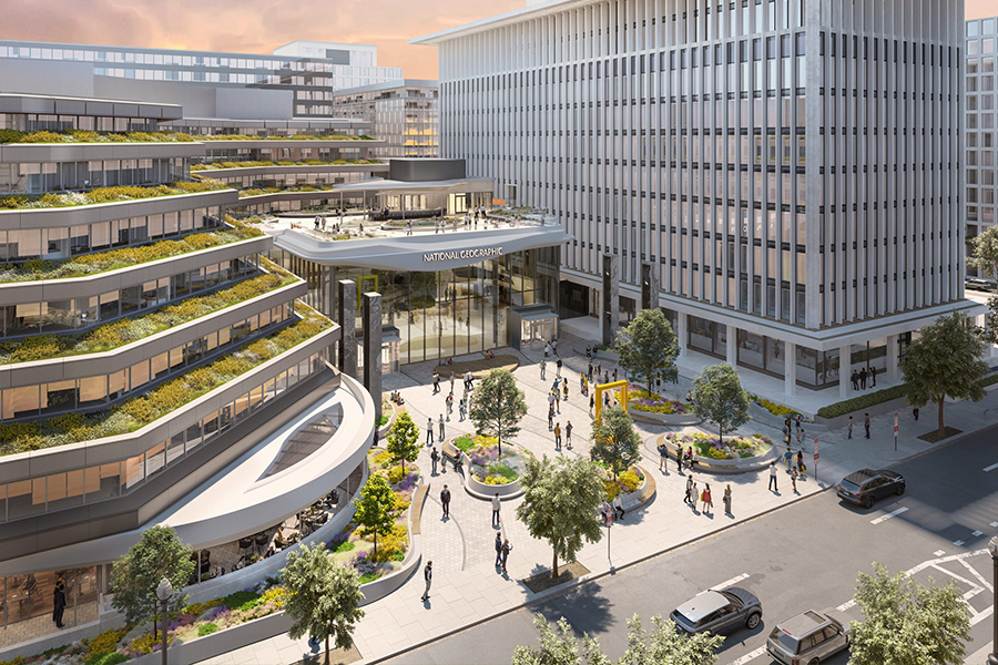
Phase two of National Geographic’s headquarters renovation brings the Museum of Exploration to DC. National Geographic enlisted Hickok Cole, OLIN, and the team to reimagine the central plaza, expand the interior experience and design a new pavilion that transforms the existing quiet entry into a dynamic destination in Washington DC. The pavilion is a showcase for storytelling, exploration and place where, visitors, members and explorers and all can meet each other and interact.
Guided by National Geographic’s mission, to illuminate and protect the wonder of our world, we combined inspiration from nature with cutting-edge digital fabrication technologies to envision and then construct the unprecedented Museum of Exploration – a cultural landmark that sets new benchmarks in both scale and innovation.
A reimagined pedestrian pathway along the campus perimeter and rich, multi-sensory plaza environment activate the new campus gateway along the busy M Street corridor. National Geographic’s iconic yellow border, referencing the design of its magazine, welcomes explorers to the campus and marks the beginning of the immersive experience.
OLIN reimagined what was previously a vehicular drop-off as an engaging, multi-sensory plaza environment for children of all ages. This flexible plaza on M Street, the expanded interior experience in the repurposed buildings, and the new pavilion and its rooftop transform the existing quiet entry into a dynamic cultural landmark that builds community in Downtown Washington DC.
Native and adapted plants provide the connective tissue that brings a unique identity to the campus and highlight the National Geographic Society’s hallmark color yellow while creating new habitat for pollinators. In the entrance plaza, a series of curvilinear planters offer shaded seating and celebrate the biomes of the world and the importance of biodiversity. These islands of planters are animated by sculptures of key species designed by the NGS team. National Geographic’s iconic yellow border, referencing the design of its magazine, invites everyday explorers to the campus and marks the beginning of the immersive experience.
OLIN was commissioned to completely redevelop the former Hewlett Packard computer company’s headquarters to create a new home for Apple. The team developed a vision to recreate a rolling topography throughout the site, characteristic of the surrounding natural condition of the Santa Clara Valley and the foothills of the Santa Cruz Mountains. The site features native woodlands and meadows, orchards, walking and biking trails, and a central gathering space with apple groves, seating areas, and a pond.
Several portions of the Apple Park landscape are designed over structure, including the landscape covering the parking access road and the landscape surrounding the Steve Jobs Theater.
Before Apple Park, this was a corporate office site that was 80% built space (buildings and pavement) and 20% green space. Today, it’s the exact opposite. This 175-acre campus is 20% built space and 80% open green space. The dense greenery cleans and filters the air, removing tons of carbon dioxide from the environment every year. We used the 2 million cubic yards of soil excavated during construction to create the Park’s hills and berms, eliminating the off-haul of over 140,000 truckloads of soil and their associated emissions. We also recycled and re-used over 90% of the concrete from the office buildings that were on this site in the construction of Apple Park.
In designing Apple Park, we were inspired by California landscapes, particularly the native oaks and foothills, and the once prominent orchards of this region. In recognition of the agricultural heritage of Santa Clara Valley, we planted over 700 fruit trees at Apple Park including plums, apricots, cherries, and of course, apples. Many of the over 7000 trees we planted here are drought tolerant.
The Folger Shakespeare Library renovation project, in collaboration with KieranTimberlake, expands public space, improves accessibility, and enhances the experience for all visitors. OLIN worked closely with the museum on the design, which replaces a surface parking lot and monoculture lawn plantings with a series of at-grade and sunken outdoor spaces, including two welcoming east- and west-facing entry plazas, a flexible event lawn, and meandering paths bordered by a mix of evergreen groundcover and seasonally diverse shrub plantings. The entry plazas and open gardens flanking the building are envisioned as a modern interpretation of the Elizabethan Garden; an evergreen hedge and groundcover plantings surround the site, clearly defining an edge, while a series of paths and benches invite visitors to linger and enjoy the immersive environment. The landscape is designed to encourage exploration and social interaction, with museum staff expanding public programs aimed to highlight the numerous plant species referenced in Shakespearean literature, which are proposed to be featured in the new design.
Located in the Hudson River Park near the Tribeca neighborhood, Pier 26 reaches out and over the Hudson River with striking views to the Statue of Liberty and One World Trade Center. The 2.5 acre pier is located within the Hudson River Estuary, a highly sensitive and ecologically productive body of water that contains a hybrid of freshwater runoff and ocean saltwater. The pier has a unique mission, providing a physical and virtual space that brings to life the invisible dynamics of the Hudson River Estuary, reflecting the current technologies and scientific understanding regarding its health, ecological successes, and challenges. The physical design of the park is a dynamic gradient experience from upland to lowland, from land to water. This experience provides opportunities for ecological education and offers recreation and leisure spaces for people of all ages.
OLIN’s winning design for the 11th Street Bridge Park Competition connects two historically disparate sides of the Anacostia River with a series of rooms and active zones, including two sloped ramps that elevate visitors to maximized look-out points to landmarks in either direction. Each ramp terminates in a waterfall that visually reconnects the ramps to the river below. In addition to demonstrating how plants cleanse captured rainwater, the waterfalls above the bridge deck provide cooling breezes and a calming sound. The waterfall below the structure collects surface river water and drops it back into the river, emphasizing the need for river aeration and higher oxygen levels. To encourage visitors to the bridge and neighboring communities, the design includes amenities for comfort and refreshment and an open plaza for markets, festivals and theatrical performances. The form of the bridge creates an iconic encounter, an “X” instantly recognizable as the river’s new image.
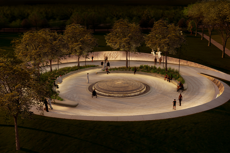
The Desert Shield and Desert Storm Memorial is an oasis rising out of the fabric of the National Mall. Nestled adjacent to the Vietnam Veterans Memorial and the Lincoln Memorial, two of the most visited sites in the nation’s capital, the National Desert Storm and Desert Shield Memorial is comparatively modest in size, but extraordinarily compelling in its layering of form and narrative of unprecedented international cooperation.
Curvilinear landforms rise and fall along the pathway which spirals toward the center of the site, their shapes evoking the image and texture of desert sand dunes. As visitors traverse the path, they approach a series of three elements which sequentially express the major themes of the conflict. The geopolitical and regional context, as well as the speed and scale of the conflict are represented by a soaring eagle and falcon, framed by a cinematic bas relief carving depicting the progression of the conflict to the liberation of Kuwait. The second element is a figurative sculpture of American servicemembers, commemorating teamwork and courage in the face of danger, the bond formed through that experience, and the post-Vietnam healing and transformation of American society following the victory and homecoming. The Unity Shield is the third element, commemorating the memorial’s central theme of global cooperation and shared service and sacrifice. Situated within an oasis-like grove, the shield incorporates a water feature and includes an engraved symbol of each coalition nation. The sculptural elements and contemplative space ask visitors to remember this turning point in history when they gaze out over the Lawn toward the Lincoln Memorial—another symbol of hard-won liberty.
The Sportsmen’s Lodge sits at a crossroads, a meeting place of the Los Angeles River and Coldwater Canyon, that has been a center of social activity and an icon of Ventura Boulevard throughout the history of the San Fernando Valley. Historically, through several eras of significance, its natural springs have drawn people to this place, and its 21st-century reimagination builds on this tradition.
The main social space is the Canyon Pass through the new retail development, which celebrates the charismatic geography of the valley, river, and mountain landscapes. The design creates a landscape that magnifies the most historic qualities of the Sportsmen’s Lodge, an inviting, visually rich, and tactile open space through the creative use of water and lush plantings.
Willis Tower stands as an icon of modern architecture, however for decades the base of the tower created an unwelcoming urban environment. The reimagination of the ground levels creates a vibrant streetscape, atrium, and roof park that is an amenity for people who work in the building but also nearby residents.
While still respecting needs for security, the previously closed off spaces around the building are now open to pedestrians, and rich textures and materials along the streetscape honor the famous gridded architecture of the tower. On the fourth floor roof park, the curving geometry interrupts the architectural grid and references the winding rivers of the Midwestern landscape with a native palette of prairie grasses and trees.
OLIN has been commissioned to develop a design for a new 400-plus acre park in Southern Indiana, along the northern shore of the Ohio River. The project will rehabilitate and transform an expanse of waterfront lands, which for decades have been occupied with landfills and industrial facilities, into a rich cultural and civic asset for Southern Indiana and the Louisville, Kentucky metropolitan area. The park was first envisioned by River Heritage Conservancy, a non-profit organization dedicated to implementing and managing a world-class park system along the northern shoreline of the Ohio Riverfront. The design will seek to regenerate and reforest the landscape, which has been dramatically shaped by both human intervention and the forces of nature. The project will also celebrate the land’s rich ecological and cultural legacy, which dates back to First Peoples’ communities established a millennium ago.
OLIN’s redesign of Columbus Circle is based on concentric rings of movement and light, transforming what was once an inhospitable traffic circle into a refuge where people stop, meet and relax in the hub of a swirl of traffic late into the evening. The fountain is formed by a series of ledges with cascading water and jets arching toward the center to reinforce the circular design and primacy of the monument, mask traffic noise and temper the summer climate. When turned off, the ledges serve as seating to avoid the typically forlorn character of unused fountains during winter months. Custom-designed benches are scaled to complement the civic space and are wide enough to allow individuals to sit comfortably back-to-back. Columbus Circle demonstrates the potential of reclaiming social space in conjunction with rethinking transportation infrastructure. The redesign devotes less area to vehicles, yet traffic now flows more efficiently. Disciplining traffic as part of transportation planning and successfully balancing it with social needs is a difficult task, but one that is successfully addressed at Columbus Circle and can serve as a model for other cities.
Three elements articulated in the new consulate compound in Hyderabad contribute significantly to its natural and designed sense of place: the role of water in the semi-arid climate; the regional geology of boulder-filled landscape; and the native dry forest vegetation, uniquely adapted to the landscape of scarce water and shallow soils. The climate is one of extremes, periods of intense dryness punctuated by severe seasonal rainstorms making water management a significant part of the history of the Deccan Plateau. Stepwell complexes and thousands of artificial lakes have been employed for centuries to collect water to support crops and provide a source of water through drought periods. The region and site are also characterized by the natural beauty of enormous granite boulders and exposed sheet rocks. India’s complex history can also be observed through the lens of its native, indigenous and evolving palette of imported plant species whose origin can be traced globally.
The design proposal weaved together these physical histories of building and landscape creating open spaces reflective of our historic and cultural ties between India and the United States. The Landscape Design, derived from the uniqueness of site and the form of the building, creates a cohesive network of arrival sequences, paths, gardens, terraces and recreational opportunities that engage the site’s natural terrain. By taking advantage of and celebrating the undulating, rocky terrain, the regional landscape is celebrated as engaging and welcoming; it remains strong but is not perceived as unyielding. Boulder fields, natural outcroppings and sinuous pathways are combined with plateaus and terraces that form natural and comfortable congregation points from where the unfolding landscape can be engaged with and observed. Gathering areas are sited in logical places, but are intended to feel episodic in design and are connected visually by means of “botanical ways” that celebrate the native flora of the region.
Located in the heart of downtown Redding, this project is the first of 10 strategic urban projects within the city of Redding. The ten sites will foreground urban residences, diversify local businesses, increase shade, improve street connectivity, and increase bicycle mobility. The 2-acre site of Block 7 is comprised of three large urban public spaces and two interior courtyards as part of a new affordable and market-rate housing development. The project’s iconic paving and furnishing design are inspired by the regional geology and ecology of Redding. Water misting systems embedded within large boulders will provide a cooling microclimate and comfortable public amenity throughout the year.
The Pocomoke Sound Corridor Resiliency Framework is a high level, forward-looking landscape scale plan that addresses ecosystem and community resiliency and adaptation as sea level rises and flooding
increases within the region. Led by The Nature Conservancy, the Framework Is an important first step intended to spur future phases will incorporate community engagement, identify specific types and locations of restoration projects, and eventually lead to the implementation of projects that bolster the regions’ ecosystem and community adaptation and resiliency.
The Pocomoke Sound Corridor is located within the Chesapeake Bay Region, encompassing towns in the Eastern Shore of Maryland and Virginia. It is already experiencing significant, daily effects of climate change and sea level rise due to its low-lying ground, subsidence, and towns connected by vulnerable infrastructure. The area is characterized by a legacy of agricultural production and culturally significant aquaculture concentrated in its small towns along the Bay. In addition to its cultural significance, the area also contains delicate and susceptible wetlands and natural areas, underscoring the importance of resiliency efforts that ensure those habitat areas are retained amid sea level rise scenarios.
The Framework was conceptualized based on the recognition that the Pocomoke Sound corridor could be a leader among similarly positioned communities facing sea level rise. The towns of Saxis, Virginia and Crisfield, Maryland have been working actively to develop plans and projects focused on adaptation and resiliency in the presence of rising tides and increased flooding and have been the recipients of major federal and state grants to further these objectives. The Framework intended to connect and support these ongoing efforts and offer a range of strategies that could be adapted for use by other communities around the Chesapeake Bay region.
OLIN was commissioned by non-profit Scenic Hudson to develop a design strategy for the transformation of a former industrial and mining site into a new 520-acre park in Kingston and Ulster County, New York, along the Hudson River. The park’s size will enable opportunities for a range of outdoor experiences from intimate hikes and family gatherings to larger community events. The park features historical remnants of brickmaking, limestone extraction and cement processing, and ice harvesting industries. The adapted structures and sublime quarried canyons reveal industrial hallmarks of the Hudson Valley’s critical role in New York State’s development while demonstrating a forward-thinking future of climate adaptation and unique disturbance ecologies.
Arising from the analysis and framework strategies, the Waterfront Improvement and Phase 1 Enhancements project which opened in November 2023. This project provides an accessible shade structure, storage area, interpretive signage, and seasonal restrooms at a restored river platform along a spur from the Empire State Trail. Hardy native plant communities suited to site conditions help absorb stormwater, mitigate erosion, and bolster the ecological value of the river terrace. The project also includes additional interpretive signage and rest areas along the new upper access road and trails. OLIN worked closely with Scenic Hudson, the Office of Parks, Recreation, and Historic Preservation, and the Palisades Interstate Parks Commission to ensure the design meets the goals and criteria of these early action projects in the new state park.
For decades, the iconic art collection assembled by Dr. Albert Barnes was displayed at his summer estate, turned museum and arboretum, in Merion, Pennsylvania. Now relocated along Philadelphia’s Museum Mile, the priceless collection is accessible to the public like never before. Conceived as a gallery within a garden and a garden within a gallery, the design honors the original Barnes estate and provides visitors with a highly personal and contemplative experience.
One of the highest profile and most cherished public spaces in the world, Bryant Park has become a model for environmental, social and economic sustainability. Many visitors to the park are unaware that the site is a large-scale green roof above an annex housing more than three million volumes of the adjacent New York Public Library. The social character of Bryant Park was transformed within days of the restoration’s completion in 1992. The New York Times cited, “Where once the park was the home of derelicts, drug dealers and drug users, it is now awash with office workers, shoppers, strollers and readers.” Today, Bryant Park draws thousands of visitors every day. The park is active year-round with concerts, performances, movie screenings, ice skating and more. The restoration of the park marked the beginning of an era in which public/private partnerships became the financiers and guardians of the public realm—a watershed moment in the history of park-making.
The Bud and Susie Rogers Garden at the Akron Art Museum is a gift to the community of Akron. OLIN worked closely with the museum on the design, which replaces a surface parking lot with a series of terraced outdoor spaces, including a welcoming plaza, a flexible lawn, a meandering path bordered by prairie grasses, and a woodland reminiscent of the forests of Cuyahoga Valley National Park. Artists are invited to use the space to create interventions and expand the dialogue of art in innovating ways. The entire garden is also designed to welcome a range of activities, including introspection, exploration, expression, social interactions and memorable art experiences, generated by the community and curated by the museum.
Nature and culture come to the forefront as the design for California Memorial Stadium artistically blends natural systems with social and environmental function. The site improvements allow the stadium and its environs to be an active and contributing part of campus, not only during games, but every day of the year. The design takes its inspiration from several site-specific themes: wilderness, history, and academic and athletic achievements, which are expressed in the materials, grading and amenities. The site’s elevations change of more than 145 feet presented opportunities for dramatic views and spaces, but made accessibility a challenge, ultimately overcome through skillful and sensitive grading. The main plaza was formed conceptually by pressing the building into the earth, minimizing the visual impact to the site, while creating an accessible and significant public open space. Materials, as one approaches the stadium, become more refined, from a coarse stonewall to precisely laid paving. The paving pattern at the plaza is intricately designed and detailed, inspired by Ellsworth Kelly’s painting La Combe III at the San Francisco Museum of Modern Art. Spirited quotations from alumni are engraved within the paving, acknowledging the university’s influence in world affairs.
The one square mile District of Caño Martín Peña is located between Luis Muñoz Marín International Airport and the resorts of the Condado District and Downtown San Juan. The district sits along the Martín Peña channel, a narrow body of water that connects the Bay of San Juan with the San José Lagoon. This unique area is both the only protected tropical estuary in the United States and home to 12,000 residents in eight neighborhoods. These residents live with severe exposures to flood risk and a lack of sanitation infrastructure, safe housing, and roads. The comprehensive infrastructure master plan is a holistic approach to community health, economic well-being, and environmental restoration through infrastructure redevelopment, water quality improvements, new housing, and climate adaptation interventions. Over a two-year inclusive planning process, OLIN led a comprehensive planning and infrastructure effort with Arcadis and eDesign Dynamics among a larger consulting team of resilience planners, architects, engineers, and transportation planners.
OLIN’s redesign of Columbus Circle is based on concentric rings of movement and light, transforming what was once an inhospitable traffic circle into a refuge where people stop, meet and relax in the hub of a swirl of traffic late into the evening. The fountain is formed by a series of ledges with cascading water and jets arching toward the center to reinforce the circular design and primacy of the monument, mask traffic noise and temper the summer climate. When turned off, the ledges serve as seating to avoid the typically forlorn character of unused fountains during winter months. Custom-designed benches are scaled to complement the civic space and are wide enough to allow individuals to sit comfortably back-to-back. Columbus Circle demonstrates the potential of reclaiming social space in conjunction with rethinking transportation infrastructure. The redesign devotes less area to vehicles, yet traffic now flows more efficiently. Disciplining traffic as part of transportation planning and successfully balancing it with social needs is a difficult task, but one that is successfully addressed at Columbus Circle and can serve as a model for other cities.
Along the length of the landmarked Fifth Avenue façade, OLIN’s design for The Metropolitan Museum of Art’s four-block-long plaza enhances one of New York City’s most significant public gathering spaces. OLIN led the design to prioritize the pedestrian experience and create a welcoming urban destination with fountains, trees, seating, and kiosks for refreshments and museum information.
Ornamental beds of shrubs and herbaceous flowers reference plantings seen in early-to-mid-20th century photographs and drawings. Trees with limited lifespans have been replaced with a formal allée of aerial hedges; in all, the plaza includes approximately 100 new trees, more than twice the previous number. Increased shade creates a more comfortable environment, reducing the surface temperature of paving by as much as 25 degrees Fahrenheit. A new pair of contemporary granite fountains operates year-round by utilizing an innovative steam-recycling circulation system. They are positioned closer to the grand stairs, improving access to the plaza’s street-level public entrances and creating an energized connection between people sitting on the steps and those at the fountains.
At the foot of City Hall and the hub of Philadelphia’s transit center, Dilworth Park has become an iconic destination in the heart of the city. Prior to renovation, Dilworth Park lacked accessible space and was divided by a series of raised and sunken terraces and blind stairways. OLIN developed a universally accessible common plaza through the elimination of stairs and walls. The new design brings the entire plaza to street level creating a contemporary public space worthy of its prominent location at City Hall. The park is constructed over Philadelphia’s transit lines and is framed by the addition of two elegant glass pavilions that create a sculptural and daylit entry to the city transit concourses below.
Dilworth Park is designed as both a relaxing refuge in Center City as well as a destination for major events. Signature park elements include the plaza, a lawn parterre for informal gathering, sinuous stonework detailing and an interactive fountain. The fountain emerges from the plaza providing a seamless scalability to the park with basins that shrink or enlarge according to the park’s activity. In the winter the fountain transforms to an ice rink providing year round enjoyment. Integrated into the fountain is artist Janet Echleman’s Pulse, a kinetic representation of the transit lines, which signal their passage through illuminated ribbons of atomized fog rising through air. OLIN collaborated with Urban Engineers, KieranTimberlake and CVM Engineers to create this vibrant and comfortable public space that establishes Dilworth Park as a welcoming space to all.
The Grace Farms Foundation sought a site design that allows people to experience the beauty of nature through landscape; creates a welcoming environment that fosters relationships; provides volunteer resources and opportunities; and enhances this bucolic environment as a place for reflection, study, and discussion. Teamed with the architects at SANAA, OLIN’s vision for the site transformed this 75-acre former horse farm into an open park composed of woodlands, meadows and ponds surrounding new buildings, as well as separate community facilities for art, social outreach and recreation. The property’s post-agrarian landscape has a unique cultural and historical narrative that will be shared with the larger community—72 of the 75 acres is openly accessible to the public. The landscape encourages ecological diversity by strategically removing invasive woodlands and non-native tree species, which will be replaced with indigenous plantings. OLIN also clarified circulation to enhance one’s experience of the site.
Commitment to quality, agrarian heritage, and the connection between people and finely crafted food was an ethos its leaders wished to be represented in every detail of their new home. In a unique collaboration with Overland Architects, OLIN produced an interweaving of building and landscape that enables all employees to enjoy and draw inspiration from the company’s roots and Wisconsin’s bountiful agricultural heritage. The new landscape is composed around and within the Home Office, sited to take advantage of views to the greater surrounding rural landscape and the dramatic Niagara Ledge. Employees arrive via a meandering drive to an orchard inspired parking court of Red Maples, then pass through the Four Seasons Garden to the Arrival Piazza, encountering sensory-rich plantings of vivid color and seasonal contrast. In the central courtyard, employees gather around a uniquely crafted common table to meet and share ideas throughout the day. Beyond the piazza sits the Heritage Orchard, dedicated to Grande’s founder Fillipo Candela, for which OLIN developed a program of grafting authentic Sicilian bud stock onto hardy Wisconsin rootstock. More than half of the 40-acre site is preserved for the continued development of orchards and meadows, which are experienced via winding paths for promoting exercise and contemplation. At its heart, Grande’s Home Office is a physical expression of its commitment to craft and focus on success through a better and more natural work environment.
OLIN led a multi-disciplinary design team to develop a master plan, design guidelines and detailed site plans for this World Heritage site. The design integrates the contemporary and historic context of Philadelphia into a successful ensemble of vehicular and pedestrian traffic patterns, open spaces and buildings—including the National Constitution Center Visitor Center and pavilion for the Liberty Bell. The process began with extensive research unveiling key issues, opportunities and constraints for the park. Stakeholders, the National Park Service and outside agencies were involved throughout the planning process, and their hopes and concerns were incorporated into the final design. The design reinforces the park’s identity and mission of preservation and interpretation of the resources and stories that symbolize the establishment of a new philosophy and nation.
OLIN’s garden design grew organically in response to the site’s context, specifically climate and light. The architectural parti strove for seamless integration of interior and exterior space. For staff and visitors, the gardens create an exquisitely appointed vestibule for the museum and set the stage for the treasures encountered within. OLIN’s design concept emerged as a reinterpretation of a classic Italian Renaissance villa and garden as a contemporary public arts institution. Italian stone pines line the entrance drive, pruned as in Rome to highlight their distinctive silhouette. A bosque of London plane trees revives the ancient horticultural practice of pollarding, a pruning technique seldom seen in the United States. All plants were carefully chosen based on their horticultural requirements, primarily water, soil and sun needs. Both native and non-invasive plants that are proven performers in the Mediterranean climate of Los Angeles were selected. The striking cacti and succulent garden serves as a model of plant selection based on extreme environmental constraints.
Centrally located in the core of downtown, Lock 3 is the primary gathering space for Akron and its environs. Prior to the re-imagining of Lock 3 , this ad-hoc space served as the City of Akron’s main public venue and functioned entirely as an event space whose primary mission is to bring people to the downtown. While the events have been somewhat successful, it is during the non-event times that the space is vacant. The locks, which are part of the Ohio & Erie Canalway system, were the lifeblood of the region that brought people, commerce and industry to Akron in the 19th century. Over time, the canal lost its significance with the emergence of the railroad and fell into disrepair. It was during the late 1960’s and early 1970’s that the Canal was deemed a National Historic Landmark and was transformed into a recreation trail along the towpath. However, locks, 2,3, and 4 remained largely disconnected from the city and the pathway to the north that leads to the Cuyahoga River Valley.
The lock system, within downtown Akron, exists in parallel with Main Street but sits nearly 16 feet below street level. OLIN’s task was to work with the City, representatives from the Ohio & Erie Canalway Coalition, and key stakeholders to reimagine Lock 3 and develop a master plan that incorporated Locks 2 and 4. This forgotten gem within the urban fabric was reconceived as a public garden and event space that brings universal access to the steep slope adjacent to Main Street. The programming was reconsidered to allow events to still function and maintain flexibility as a comfortable, everyday place for Akronites to gather and be outside. The signature elements of the space are the Lawn Bowl Amphitheater and Balcony, which takes advantage of the site’s topography, and The Play Loop that connects Locks 2 and 3. The Play Loop is a series of play spaces that are characterized by different ecotypes of NE Ohio; they are the Grass Moraine, Forest, Sand Bog, River Valley, and Misty Plains. The Misty Plains also transforms into an ice-skating loop during the winter months, hence making the space a place to inhabit year-round. OLIN is excited to be a part of this revitalizing effort in creating a welcoming and vibrant downtown place in the City of Akron.
For decades, Mill River in Stamford, Connecticut was dammed and channelized, choked with pollution and silt buildup, leading to greater flood risk for the surrounding downtown. When the Army Corps of Engineers called for the removal of the dam and channel walls, OLIN was brought in to create a master plan for the newly naturalized waterfront. The plan envisioned the river as an amenity and connector, anchored by a park to the north and with a multimodal greenway stretching down to Stamford Harbor. The first phase of the plan, Mill River Park, was implemented directly out of OLIN’s master plan. The park embraces the newly naturalized banks with a design that includes passive meadows, pedestrian and bicycle trails, lawn areas for play and events, and—for the first time in decades—access points down to the water’s edge. The park also incorporates an existing cherry tree grove, a beloved landmark in Stamford that was a gift to the city in 1957 by Junzo Nojima, a Japanese immigrant. Future phases of the park development include a fountain/ice rink and additional permanent visitor amenities, as well as trail connections extending beyond the park to Stamford Harbor.
The Museum of the American Revolution is located in the historic heart of Philadelphia, just blocks from Independence Hall. In collaboration with Robert A.M. Stern Architects, OLIN led the landscape design for the public spaces along each of the streets. On Chestnut Street, long benches provide comfortable seats for viewing two large bronze bas-reliefs depicting events from the revolutionary period. On 3rd Street, a café terrace offers views toward the historic First Bank building designed by Samuel Blodgett. The museum’s entrance at the corner of 3rd and Chestnut is set back on a sympathetically scaled plaza, allowing for ease of circulation and occasional events. The plaza also marks the beginning of the museum experience, with a display of revolutionary-era cannons facing outward toward the street.
The National Veterans Memorial & Museum is a monument to honor the fallen and recognize the service and sacrifice made of all veterans in every branch of the military. As an extension of this purpose the landscape is intended to provide a natural sanctuary for remembrance and reflection. The central component of the design being a memorial grove, a ceremonial stand of trees, a sacred space for rest and meditation surrounded by a series of outdoor rooms designed for memorial displays and commemoration. A tree-lined pedestrian walk encompasses this landscape while gradually rising to a height overlooking the Scioto River and downtown Columbus beyond. This project is being implemented out of a larger master plan for the Scioto Peninsula in Columbus, developed by MKSK and OLIN.
The Octavius V. Catto memorial celebrates the 19th century civil rights activist, educator, and scholar who dedicated his life to the abolition of slavery and the establishment of equal rights for all, regardless of race. The memorial is situated adjacent to Philadelphia’s historic City Hall and is the first sculpture of an African American to be located on City of Philadelphia public property.
OLIN and our team of local consultants collaborated with artist, Branly Cadet, to site and implement three main sculptural elements which reveal the story of Octavius Catto. A granite abstraction of an 1860’s horse-drawn streetcar stands behind the figure of Catto, who, a century before Rosa Parks, sought to desegregate the horse-drawn streetcar by waging protests and sit-ins. Catto’s figure stands before a steel representation of a mid-nineteenth century ballot box reflecting his efforts to get the Fifteenth Amendment to the U.S. Constitution ratified in Pennsylvania, giving all men—regardless of race—the right to vote. The distinctive bronze figural sculpture of Octavius Catto leans forward with outstretched arms, serving as an invitation to the public to see themselves as active agents of change.
Philadelphia’s 30th Street Station is one of the busiest and most iconic transit hubs in the nation. Its location at the nexus of Philadelphia’s Center City and University City Districts also makes it potentially one of the most valuable tracts of real estate in the city. Amtrak, Drexel University and Brandywine Realty Trust engaged a multidisciplinary team including SOM, OLIN and Parsons Brinkerhoff, to develop a new master plan for the 30th Street Station precinct. Building upon a number of ongoing initiatives, this thirty year plan aligns the goals of multimodal transportation, urban development and economic resurgence under one umbrella.
OLIN is a core design and planning member of the Red Hook Housing restoration plan led by Kohn Pedersen Fox. During Hurricane Sandy Residents lost heat, power, in some cases water for weeks, with many stranded in their apartments or left unable to return for weeks. The storm permanently damaged the majority of the electrical and heating systems and most of the buildings are still using temporary boilers. NYCHA has commissioned a design and engineering team to make the houses more resilient and reimagine the campus to be more livable and efficient as part of approximately of a comprehensive Community Development Block Grant-Disaster Resilience (CBDG-DR). The team developed strategies that address the challenges inherent in adapting aging buildings to be sustainable, support a social environment that supports health and wellness, and incorporate resilient strategies to withstand the next superstorm.
This reclaimed brownfield on Oakland Bay was previously the site of freight railways, dirt pathways and warehouses. As part of the design considerations, OLIN developed on-site remediation strategies to isolate contaminated soils from non-contaminated soils. Today, the park features inviting expanses of lawn, canted and oriented to provide maximum views to the bay. The lawns are edged with a series of low seat walls, reminiscent of lapping waves on shore. Tucked into and between the seat walls are shrub and perennial plantings native to California and coastal areas. The plantings on the waterside edge of the park ebb and flow along the promenade. Atop a mounded landform sits Cupid’s Span, a commissioned piece of large-scale sculpture designed by Claes Oldenburg and Coosje van Bruggen. OLIN worked with the artists to determine the placement of the piece. Given the multiple interpretations of the artwork—Cupid’s bow and arrow, a ship, a part of the nearby bridge span, or a quill, among others—it was determined that the sculpture should sit like a ship, gently rolling off the crest of a wave.
Formerly a parking lot the size of a city block, Simon and Helen Director Park is now a vibrant urban piazza in downtown Portland. The park, built entirely atop an underground parking garage, has created a variety of public spaces within the site's compact footprint, with a range of microclimates, amenities and activities. A glass and wood trellis stands out as a signature element of the plaza, offering shaded seating and a café without disrupting views throughout the space. An interactive fountain element anchors the northwest corner of the site, partially bordered by an ipe wood bench, and on the southern edge, a small grove of trees frames a giant, whimsical chessboard. Amid this vibrant civic experience, the park also incorporates strategies for urban greening and stormwater management, including a green roof on the café, planting beds which filter and reserve runoff for irrigation, and even the trellis and paving, which are designed to direct rainfall into the park’s catchment system.
OLIN’s open space vision for the 2012 Master Plan for the Central Delaware called for an extensive wetlands park on the derelict piers and silted in slips south of Washington Avenue. In 2019, OLIN, leading a team that includes AES and Quantum Translations, was hired to develop a conceptual plan and preliminary documentation for the first phase of this wetlands park. South Wetlands Park will serve as a critical urban link between the residents of South Philadelphia and an ecologically robust Delaware River waterfront. It is an opportunity to engage adjacent neighborhoods in meaningful ways, to reinvigorate and protect an endangered habitat, and to create a space for residents to become stewards of their environment. OLIN’s vision is access to wild beauty for all: a place where Philadelphians can immerse themselves in the very ecology that sustains the planet and its inhabitants.
Located next to Target Field, the station serves as a central, multi-modal transportation hub and community gathering space in downtown Minneapolis. A catalyst for neighborhood redevelopment, the $82 million design-build project provided 300 new jobs during its construction, and created new community park space for the North Loop neighborhood and historic Warehouse District. The station links 488 trains from light and commuter transit networks, and connects daily bus operation and miles of biking and walking trails linked within the Twin Cities Metropolitan area. The interchange includes an urban plaza with areas for neighborhood bars and eateries, cultural amenities, and entertainment. A great lawn in the upper plaza serves as a central green “stage,” providing new space for pre-game events, community concerts, and seasonal events. Located atop a parking structure, the project provides for 250 additional parking spaces within the transit hub. The landscape and infrastructure are fully integrated, with stormwater cisterns that can hold over 40,000 gallons. Stormwater filtering and reuse have reduced runoff from the Target Field Station site by 27% and total suspended solids in the runoff by 97%.
The Truman Presidential Library and Museum is located on 14 acres of gently rolling terrain in Harry S. Truman’s hometown of Independence, Missouri. It is one of fifteen Presidential Libraries in the United States and is managed by the National Archives. The library was established in 1957 with the mission to keep President Truman’s life and legacy alive and preserve and provide access to President Truman’s historical materials. Over the last five years, this world-class Presidential Library and Museum has undergone a series of state-of-the-art building renovations and exhibition updates. The capstone project of the library and museum renovation is the grounds reimagination led by OLIN.
The new Stuart Weitzman Plaza, home to the school’s graduation ceremony and other events, reinvigorates the setting of the School of Design to play a unique role in the life of the school and campus. Reshaping space at this key nexus of campus pedestrian circulation brings together the Fisher Fine Arts Library, the Graduate Fine Arts Program in Morgan Hall, the Architectural Archives and Meyerson Hall in new ways as a place where human connections are made, ideas hatched and where people can connect with nature and the campus as a whole.
At once a place of gathering, exchange, and movement, the project comprised brick and stone paving restoration, upgraded lighting, new tree planting to its west, the installation of two new wood benches cumulatively 80’ in length and a new stepped terrace to 34th Street. A new and generous flight of steps leads from the plaza to 34th Street and Smith Walk, strengthening connections to the eastern areas of campus. Broad terraces formed with locally-sourced, heat-treated ash frame the steps and provide seating and gathering for students and the community alike. Shade is provided by five yellowwoods, recalling the grove of yellowwoods that occupied the area prior to the construction of Meyerson Hall.
The plaza project was originally conceived as a part of the school’s masterplan of 2012 and continues the University’s decades-long initiative of forging more positive connections with its local urban fabric and community. By forming entries to facilities from the adjacent streets, removing barriers to circulation, improving sightlines, and forming more generous public spaces around the perimeter Weitzman Plaza takes its place in forming a more open and welcoming presence for the school and campus in its neighborhood.
The northeast precinct of the University of Washington is a distinct campus landscape, possessing a unique natural character, unspoiled by the built environment of the bustling academic campus situated within. Distinguished by its associations with the iconic landscapes of the Pacific Northwest, the north campus is defined by its forest-like canopy of trees and iconic views from the eastern ridge, overlooking the Cascade Mountains and Union Bay. The design intention for the North Campus Housing project is to unite the open space and new residence halls together in a continuum, integrating the cultural and sylvan elements of the campus. Throughout the design process, careful consideration was taken to maintain the scenic views and natural character of the precinct.
OLIN’s landscape design is a synthesis of the U.S. government’s goals for sustainability, security, accessibility and design excellence; with a team led by KieranTimberlake, OLIN crafted an embassy design that gives form to the core beliefs of democracy—transparency, openness, and equality—in a way that is at once secure, welcoming, and sustainable. OLIN’s competition winning landscape is a contemporary approach to the English tradition of urban parks and gardens as the context for civic buildings. The design’s spiraling walks and sculpted meadow terrains form the Embassy grounds, winding into the lobby and promenade overlooking a freshwater pond and the Thames to the north. The landscape design expresses these ideas formally but also through the selection of landscape materials. The spiral continues up through the building in interior gardens based on six significant American landscapes. Plantings chosen for the project were selected on the basis of commonalities between species common to the United Kingdom and the U.S.—a result of their being brought by English settlers and explorers to the New World. The result is a true embodiment of the United States’ deep bond with the U.K., the embassy’s connection to the city and people of London, and the fundamental tenets of American democracy.
The design of the revitalized Washington Monument grounds is bold and clear; a minimalist solution that turned a project originally funded to prevent terrorism into a handsome civic amenity. It demonstrates that the union of sound security and artful design is not only possible, but can also be functional and graceful. The Washington Monument’s 72-acre grounds serve a vital cultural and civic role, providing a public space for demonstrations, celebrations and recreation for millions of people each year. A need to upgrade exterior security provisions came to the forefront after 9/11, leading to an invited design competition for the monument grounds. OLIN won the competition with an elegant security solution, and in the process, successfully proposed much needed landscape improvements. The design brings resolution to the landscape deftly. Representative of this are the low granite walls configured in a graceful pattern appropriate to the spirit of the Mall and the monument. The walls are key to the design and serve to protect the monument, provide visitor seating and assist with retaining the grade to make paths accessible. New plantings, lighting, furnishings and a granite-paved plaza at the base of the monument breathe life into the visitor experience and foster interaction with the cherished and iconic memorial.
One of the most revered concert halls in the world, Carnegie Hall has been a cultural landmark in New York City for well over a century. In order to modernize its facilities and expand its public education program, the institution has renovated the two studio towers above the auditoriums. The renovation has created an opportunity for a rooftop garden and event space above the hall. Several hundred people can be accommodated in this vertically verdant landscape. The garden, along with stormwater systems that capture rainwater for irrigation and reflective pavement to minimize the heat island effect, will contribute to the goal of an LEED-certification for the building.